
Residential Land For Sale

€116,000
Anderson, Missouri, United States
1,618,740 sqm
Listed By: Listanza Services Group
Listed On: 06/09/2023
Listing ID: GL5287250 View More Details
Description
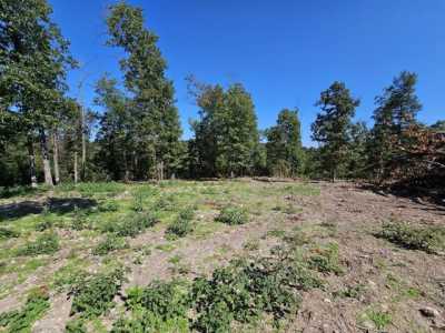
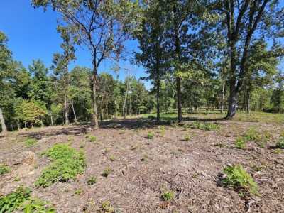
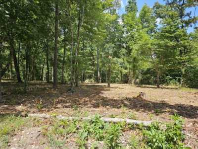
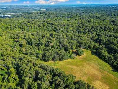
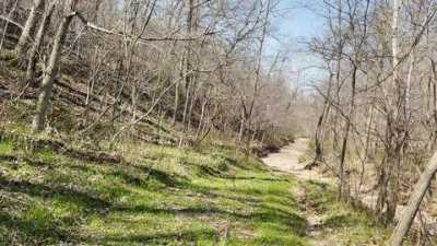
Located in Anderson.Cheap Land In Missouri If you're looking to get away from it all, this sprawling, remote "back 40" deep in Missouri Ozark country is for you. Nestled in a fertile wildlife area, you'll be able to bag that trophy deer you've always wanted, or take a run at smaller game like turkeys or rabbits. This 40 acre wilderness compound is ready for your RV, camper, cabin, home . . . or leave it as-is and simply enjoy nature's splendor. The rolling hillsides here are also great for hiking or 4x4ing or meander to the west just a few steps to canoe or fish at nearby Indian Creek. The feeling of quiet, privacy and remoteness is enhanced due to the fact that this parcel is surrounded by forest with 50 foot tall trees all the parcels that surround it are wooded, with no improvements or structures. It's close enough to U.S. highways though, so that when you're ready to get out and go, you'll be on your way in no time. If you're looking for something bigger than 40 acres, then we'll cut you off some more. This piece comprises one quarter of a 160 acre parcel, but you can have half of it, 80 acres, for $225,000, or the whole 160 acres for $398,700. Because there are NO RESTRICTIONS, you have a massive 40 acres of blank canvas here, perfect for any hunter, ATV rambler, outdoor enthusiast, or budding land developer. You won't find a cheaper 40 acres in this coveted region of the Missouri Ozarks. Hunting and Recreational Land For Sale In McDonald County, Missouri This property is just 10 minutes from Anderson, MO, which is a small town where you can access basic amenities such as a market, dollar store, post office, etc.. You'll find the nearest Walmart in Neosho, just a 30 minute drive from here. Its name has an Indian derivation meaning clear or abundant water and you'll see these clear springs still flow freely throughout this entire region, especially at Big Spring Park, where almost a million of water gush from the hillside each day. Flower boxes and planters adorn many of the storefronts and sidewalks around the city square, and today is nationally recognized as the "Flower Box City." Naturally, it's home to the "World's Largest Flower Box" a railroad gondola car filled with flowers, shrubs, and trees. Joplin, MO is 45 mins away A mid-sized but vibrant city located at the intersection of 44, 49 and Historic Route 66. Joplin has a bustling downtown and is an up-and-coming city with a notably low cost of living. There are great restaurants, hotels/RV parks/camp sites, and community events including sports, live music, performing arts, family-oriented programming, arts and outdoors! Here, you can also find many amenities and conveniences such as Walmart, grocery stores, banks, doctors offices and a hospital, schools, hardware stores, and churches. Joplin is also home to Missouri Southern State University, Kansas City University Joplin, and Ozark Christian College. Rogers, AR is just 45 minutes away in the opposite direction of Joplin, and is a beautiful city in Benton County, NW Arkansas. With a population of approximately 70,000 it's known for its beautiful downtown, and its accessible recreation with sports parks, neighborhood parks, an aquatic center, a skateboard and splash park, athletic fields, a YMCA, two lakes, five golf courses, and a trail system totaling over 23 miles. The NWA Razorback Regional Greenway is a 36-mile primarily off-road shared-use trail that connects the region's trail systems to various community attractions. Forester Park is home to the largest soccer program in the state. Here you can access any of the amenities and necessities you may need including doctors, restaurants, shops, pharmacies, churches, Wal Mart, hardware stores, banks, and more. The nearest airport is Northwest Arkansas National Airport, just 12 minutes from Rogers, which offers on average 50 direct flights a day to 19 major U.S. cities. Branson, MO is about 2 hours away, an Ozark town in SW Missouri known as a beautiful and fun family vacation destination. From outdoor fun, to amazing live entertainment, there's no shortage of great things to do. Enjoy fishing on Table Rock Lake; hit the rides at Silver Dollar City an 1800s-themed amusement park with live music; Play a round at a local golf course; Visit a local winery, Fly over the Ozarks in a helicopter or soar over on a zip line; Plan a tranquil day at a luxurious spa. Here you can find groceries, restaurants, hotels, doctors, and many other basic and important amenities. This is Ozark Country, after all, so more outdoor recreational opportunities abound, including: Neosho River this massive and winding river 40 minutes away just across the state line in Oklahoma hosts the Grand Lake Casino, when you're in the mood to roll the dice!Go treasure hunting at the Old Spanish Treasure Cave about a half hour away, a cave that features a guided tour through one of the Ozark's biggest mysteries. This cavern is filled with fascinating legends of hidden treasure buried by the Spanish Conquistadors. Learn why the unsolved mystery of the hidden treasure has kept the secrets alive in this cavern and why it is believed the treasure is still here.For decades, those that seek the most scenic destinations in the Ozarks and Missouri have come to Grand Falls near Joplin. As the largest, continuously flowing natural waterfall in Missouri, Grand Falls plunges 12 feet down a 163 foot wide ledge of solid chert before crashing into jagged crags and drifting southward in peace.Other recreational attractions in the surrounding area include Beaver Lake, Hobbs State Park Conservation Area and War Eagle Mill Cavern to the east of Rogers, as well as historical Civil War battlefield, Pea Ridge National Military Park, about 10 miles outside of Rogers.Venture into Flag Springs Conservation Area 4000 acres of beautiful forested land full of oak, hickory, and cedar trees. There are hiking, biking and horseback trails throughout. Flag Spring, located on the West side of the property, flows year round. Hunting is permitted in the area according to the appropriate season. Deer and squirrels abound; it's also stocked with wild turkeys. There's also a shooting range on Flag Springs. Call Scott directly at 314.639.9777 if you have any questions or would like to discuss making an offer. There's lots more info including viewing instructions below, so make sure to keep reading! This drone video covers the entire 160 acre tract from which this 40 acre tract is cut. If you want the whole 160 acres, just let us know! 40 AcresMcDonald County, Missouri; 64831Nearest cities/towns: Anderson, Neosho, JoplinAPN: 04-7.0-35-000-000-004.000Legal Description: SE 1/4 of NW 1/4GPS Coordinates (center of lot): 36.681527, -94.362010Dimensions (approximate lot not surveyed): 1320 feet x 1320 feet x 1320 feet x 1320 feetThis property is NOT in a flood zone.Elevation: 1093 FtTerrain: rollingAccess: dirt ranch road easementWastewater: Septic system necessaryWater: Well necessaryElectricity: none. Local power company is New Mac Electric Co-Op (417) 451-1515Annual Taxes: $55.68 in 2020Zoning: NONE do what you want with your land! Homes and accompanying outbuildings such as garages, workshops, barns permittedNo size/height restriction on homes/structures on the lotNo setback requirementsNo time limit to build leave the lot as-is for as long as you want or need.RVs, Campers, Mobile Homes, Cabins, "Shouses", tiny-houses all permitted.Animals, livestock etc permittedNo HOA or CC+R'sOr, simply leave it as-is and enjoy being surrounded by nature!McDonald County Website + ContactsAssessor (417) 223-4361Treasurer (417) 223-7514Clerk (417) 223-7530Recorder (417) 223-7523 You can go view the property at your convenience owner does not need to accompany. Please call/text us to let us know you're heading out, so we can ensure we have our phone on us in case you need help or have any questions. We'd appreciate a couple hours notice if possible. DRIVING DIRECTIONS: Click HERE to open the destination in Google Maps, and simply enter your starting point to get step-by-step directions. From this link, youcan press "Directions" (on the left), enter your starting point, and Google Maps will provide you with step-by-step directions.You can also click "Send to Phone" if you're viewing this on your computerAnd "Save" to download the directions so they'll still work if you lose cell service. If for some reason you're having trouble with that link, you can navigate to GPS Coordinates 36.681527, -94.362010. WALKING THE PROPERTY LINES w/YOUR PHONE: We highly recommend a FREE app called BaseMap, which uses your phone's GPS system to show you property boundary lines, and allow you to walk them in real-time. You can follow THIS LINK to see the center of the lot on BaseMap (you'll need to have the app to open the link). Make sure to save it as an Offline Map (by hitting the big green '+' button on the map, then hit 'Go Offline') before you head out so that you can use the app even if you lose cell service. This is by far the best method to follow the boundary lines of the property. This is a very important tool to learn BEFORE you head out there. Please call us if you have any questions about it. If you're interested in making an offer Call Scott directly at 314.639.9777 if you'd like to discuss making an offer. FOR SALE BY OWNER: we are investors, and are selling this lot For-Sale-By-Owner. You do not need to submit your offer through a real estate agent, and in our experience we close transactions more quickly and easily by having our dedicated transaction coordinator work directly with the Title Company and Buyers. We will also both save money on commission/fees by cutting out agents as the middle men. However, if you feel strongly about working with a Realtor, then you're welcome...